Monday 22 August 2016

Maps is fast again!

I just released a bunch of Maps releases.
  • 3.21.90
  • 3.20.3
  • 3.18.4
  • 3.16.4
  • 3.14.4
  • 3.12.4
  • 3.10.4

All of them speeding up the fetching of tiles in two ways.
  1. By downloading a service file telling us where third-party tile servers are instead of using redirect by proxy
  2. Allowing for more consecutive HTTP requests
Number 2 is only available by using the (as of now unreleased) version 0.12.4 of libchamplain.

Once your distro of choice picks up one of these stable releases you should be back to at least the old Mapquest speed of Maps. And if your distro upgrades to latest libchamplain when it arrives you will see even greater speeds.

And as a bonus, the latest libchamplain release will bring horizontal map wrapping, courtesy of excellent GSoC student Marius Stanciu!

Sunday 31 July 2016

Maps has tiles again

This is a short post to inform you all that Maps has tiles again. We now get our tiles from Mapbox, with whom we have made an agreement going forward. We access Mapbox through a GNOME based redirect, so that we could redirect to something else if a similar situation would arise again.

Maps has been released with the new tiles in the versions:
3.21.4
3.20.2
3.18.3
3.16.3
3.14.3

And I think at least Fedora has been updated.

So, while it was unfortunate that MapQuest closed down for us and we were caught off guard. We now have a better tile setup than before and more options going forward.

More information about our setup with Mapbox will come from a blog post on Planet GNOME soon. I will leave you with a taste of the new tiles.


Saturday 16 July 2016

Getting a network trace from a single application

I recently wanted a way to get a network packet trace from a specific application. My googling showed me an old askubuntu thread that solved this by using Linux network namespaces.

You create a new network namespace, that will be isolated from your regular network, you use a virtual network interface and iptables to make the traffic from it reach your regular network. Then you start an application and wireshark in that namespace and then you have a trace of that application.

I took that idea and made it into a small program, hosted on github, nsntrace.

> nsntrace
usage: nsntrace [-o file] [-d device] [-u username] PROG [ARGS]
Perform network trace of a single process by using network namespaces.

-o file     send trace output to file (default nsntrace.pcap)
-d device   the network device to trace
-u username run PROG as username 

It does pretty much the same as the askubuntu thread above describes but with just one step.

> sudo nsntrace -d eth1 wget www.google.com
Starting network trace of 'wget' on interface eth1.
Your IP address in this trace is 172.16.42.255.
Use ctrl-c to end at any time.

--2016-07-15 12:12:17--  http://www.google.com/
Location: http://www.google.se/?gfe_rd=cr&ei=AbeIV5zZHcaq8wfTlrjgCA [following]
--2016-07-15 12:12:17--  http://www.google.se/?gfe_rd=cr&ei=AbeIV5zZHcaq8wfTlrjgCA
Length: unspecified [text/html]
Saving to: ‘index.html’

index.html                                         [ <=>                                                                                                   ]  10.72K  --.-KB/s   in 0.001s 

2016-07-15 12:12:17 (15.3 MB/s) - ‘index.html’ saved [10980]

Finished capturing 42 packets.

> tshark -r nsntrace.pcap -Y 'http.response or http.request'
16   0.998839 172.16.42.255 -> 195.249.146.104    HTTP 229 GET http://www.google.com/ HTTP/1.1
20   1.010671    195.249.146.104 -> 172.16.42.255 HTTP 324 HTTP/1.1 302 Moved Temporarily  (text/html)
22   1.010898 172.16.42.255 -> 195.249.146.104    HTTP 263 GET http://www.google.se/?gfe_rd=cr&ei=AbeIV5zZHcaq8wfTlrjgCA HTTP/1.1
31   1.051006    195.249.146.104 -> 172.16.42.255 HTTP 71 HTTP/1.1 200 OK  (text/html)

If it is something you might have use for or find interesting, please check it out, and help out with patches. It turns out I have a lot to learn about networking and networking code.

All the best!

Maps and tiles

Hello all!

Right now we are having infrastructural problems with Maps. We can no longer use the MapQuest tiles, see mail thread from maps list archive here for more information.

We are working on getting past this and getting a working Maps application released soon. But this is also showing us more clear that we need to get a better grip around the tiles infrastructure if we want to have a Map application and/or a Map infrastructure in GNOME. We are having good discussions and I think we will get through this with a nice plan forward to prevent stuff like this happening. And also with a plan to do better in the future and do cooler stuff with tiles.

All the best!

Tuesday 1 March 2016

Walkthrough of Maps 3.20 release notes

We have now entered beta period for GNOME 3.20 and the release notes for Maps are starting to look final.

This blog post will expand a bit on the official release notes, adding screenshots and some reasoning to most of the items.

Map bubble re-work

For this cycle we wanted to add some more meta-data to our small map bubbles. But at the same time we thought that the bubbles were kind of cluttered.


So we added a way to expand the bubble, so that we show the minimum amount of information by default. And only show more if user presses the more information dots.


This is sort of a stop-gap feature. For 3.22 we want to do a more ambitious re-design of how we show information about a place on the map.

For this release we added website, phone number, internet access and altitude information, if available, to our map bubbles.

Editing items on OpenStreetMap

One of the things I am most excited about in this release of Maps is the ability to edit and add places on OpenStreetMap. It is due to most awesome work by Marcus Lundbladh. We now have an edit symbol on our map bubbles. If you press it you will be prompted for your OpenStreetMap credentials. Or a link to where you can set up an account.


After that you get an editor view where you can update the object on OpenStreetMap.


It is also possible to add a new node to OpenStreetmap.
By using the map context menu and choosing Add to OpenStreetMap.
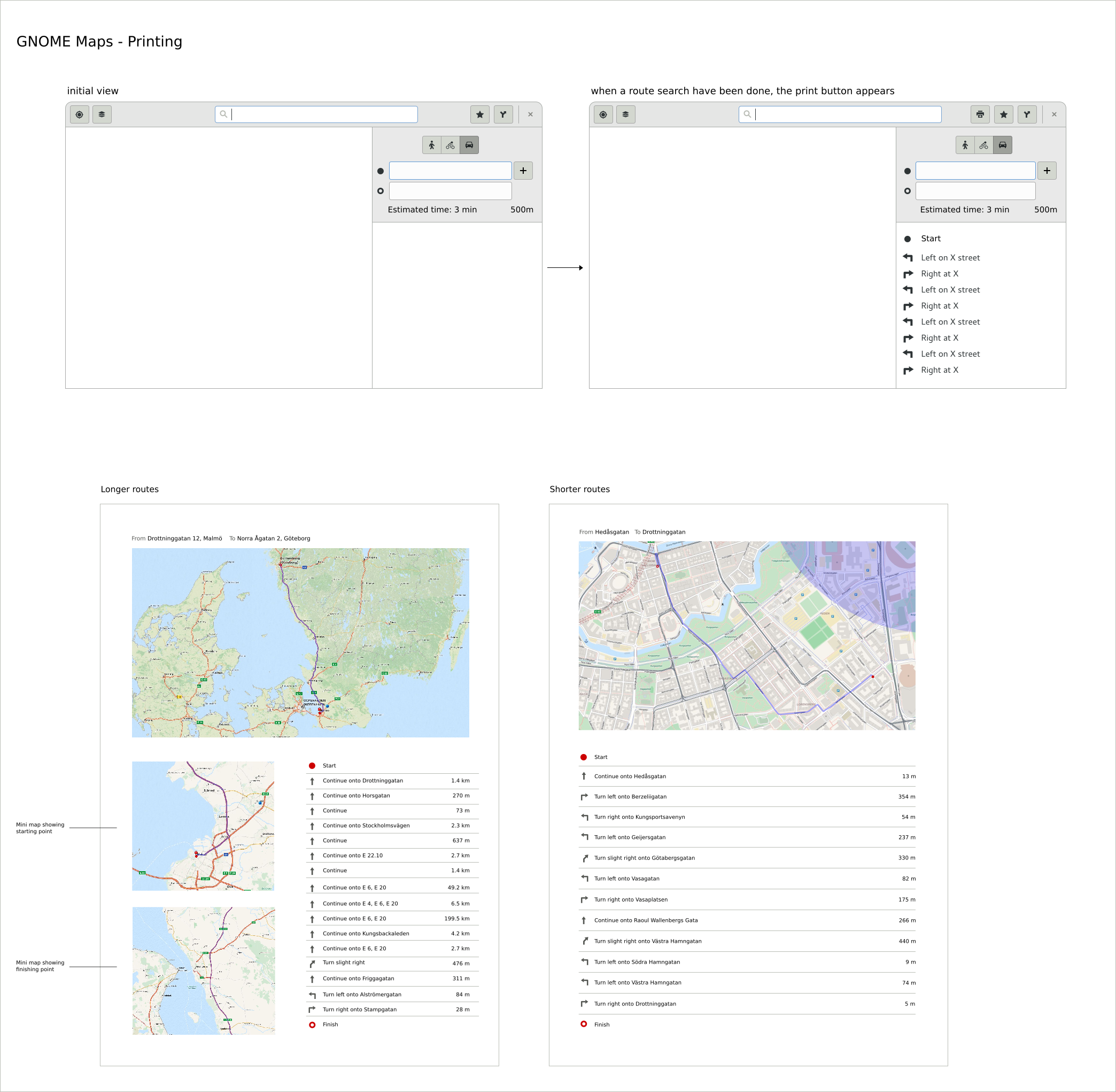
Printing of routes

Due to excellent work from our Outreachy intern Amisha we managed to land printing of routes this cycle. This is something we have wanted for a while. It helps us cover some of the offline niche. You can search for a route at home, print to paper or PDF and bring that with you on a journey where you do not have access to net.


When you have successfully search for a route a print icon will appear in Maps header bar. From there one can initiate printing.


Right now you will get one of two print layouts, depending on the distance of the route. The image above is of the long route layout.

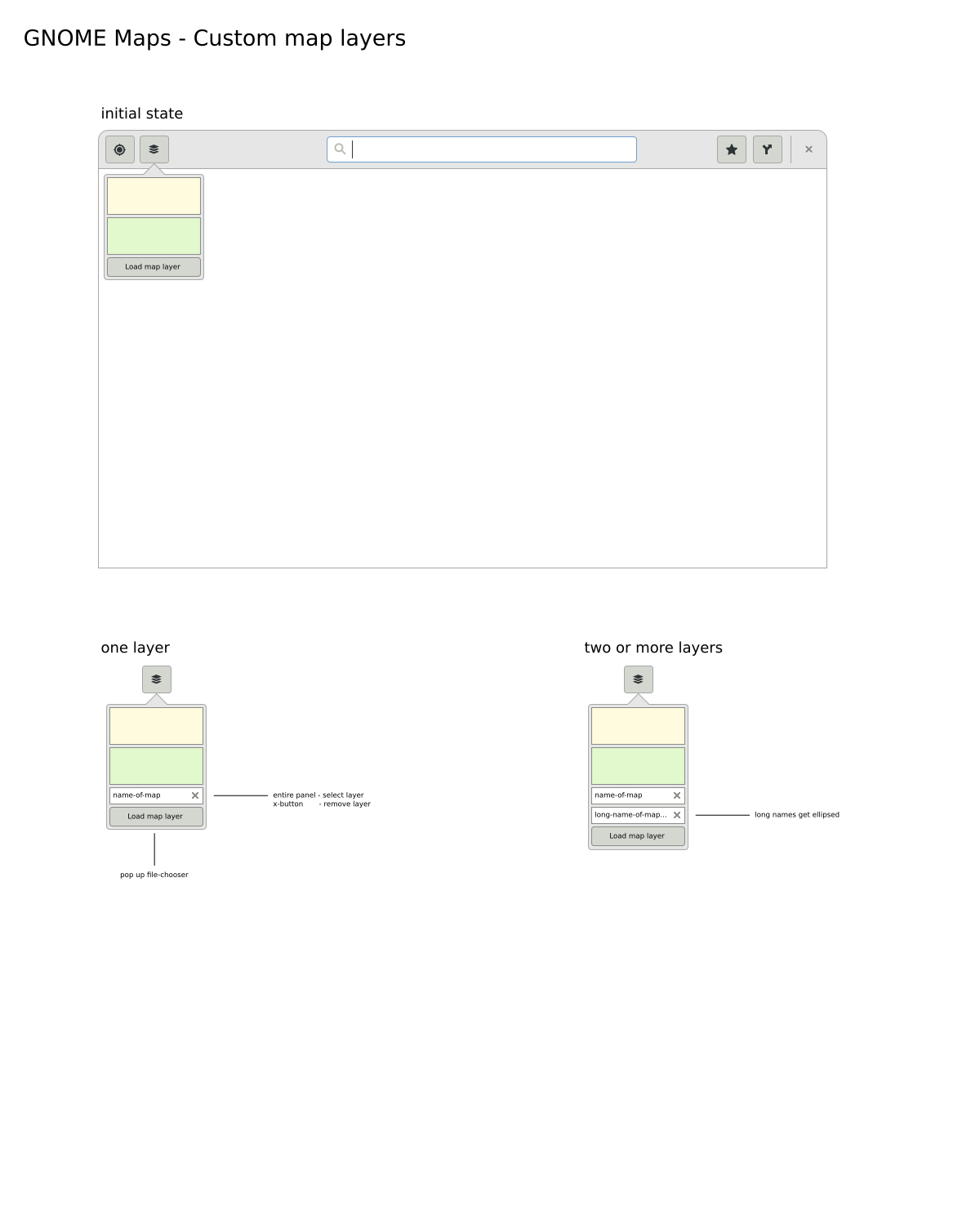
Adding of custom map layers

Hashem, another one of our Outreachy interns, has contributed a lot to Maps this cycle. A lot of small details here and there. The most visible contribution is support for KML and GPX layers, as well as an UI to handle them in Maps.

Maps now registers as a handler for the mime-types of GeoJSON, KML and GPX. Which means that Maps will be a suggestion from GNOME when you attempt to open files of those types on the web or on the desktop.


It is possible to open layers through the UI, the command line and through drag and drop to an open Maps window.
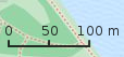
For GeoJSON we also support the Mapbox simple style specification.

Scale ruler


A minor change UI wise and code wise, but one that was requested for some time was merged this cycle. The adding of a scale ruler to Maps. It is visible in the bottom left corner of the images above.

Exporting of view to PNG

The library that contains our map widget, libchamplain got support for exporting a view to a cairo_surface. That meant that we could implement the feature of exporting to PNG quite easily.


This is triggered by the map context menu.

Handling geo: URI

The geo URI scheme is a way of linking to a certain location. Maps is now registered as a handler of this URI. So if you encounter it in the wild, say in your web browser. Try to click it and Maps should be your suggested agent for it.

We can also get a geo URI from Maps, by using the Copy Location item in the map context menu. It is also possible to paste or enter a geo URI in the Maps search bar to have Maps go to the location, or give one on Maps command line.

Help overlay

Along with many other GNOME apps we added a help overlay to show our shortcut bindings.


Monday 4 January 2016

Maps and Outreachy

Outreachy is the successor of the Outreach Program for Women (OPW). OPW was inspired by Google Summer of Code and by how few women applied for it.

The program was renamed to Outreachy with the goal of expanding to engage people from various underrepresented groups and was moved to Software Freedom Conservancy as its organizational home.

For this period (December 2015 - March 2016) Maps has two Outreachy interns!

Amisha Singla will be working on adding the possibility of printing the route in Maps. Working towards the preliminary mockups done by Andreas Nilsson

Her blog has been connected to Planet GNOME but to see her earlier blog post please se the direct link here.


Hashem Nasarat will be working on bringing support for KML/KMZ to Maps.
as well as formalizing the UX and UI for dealing with custom layers.

He is currently working on realizing these mockups:
His blog is also on Planet GNOME and the direct link is here.

Both interns are doing awesome work and we are very very lucky to have them! Maps needs them and also you! For doing design, code evaluation of infrastructure and work flow!